City Guide
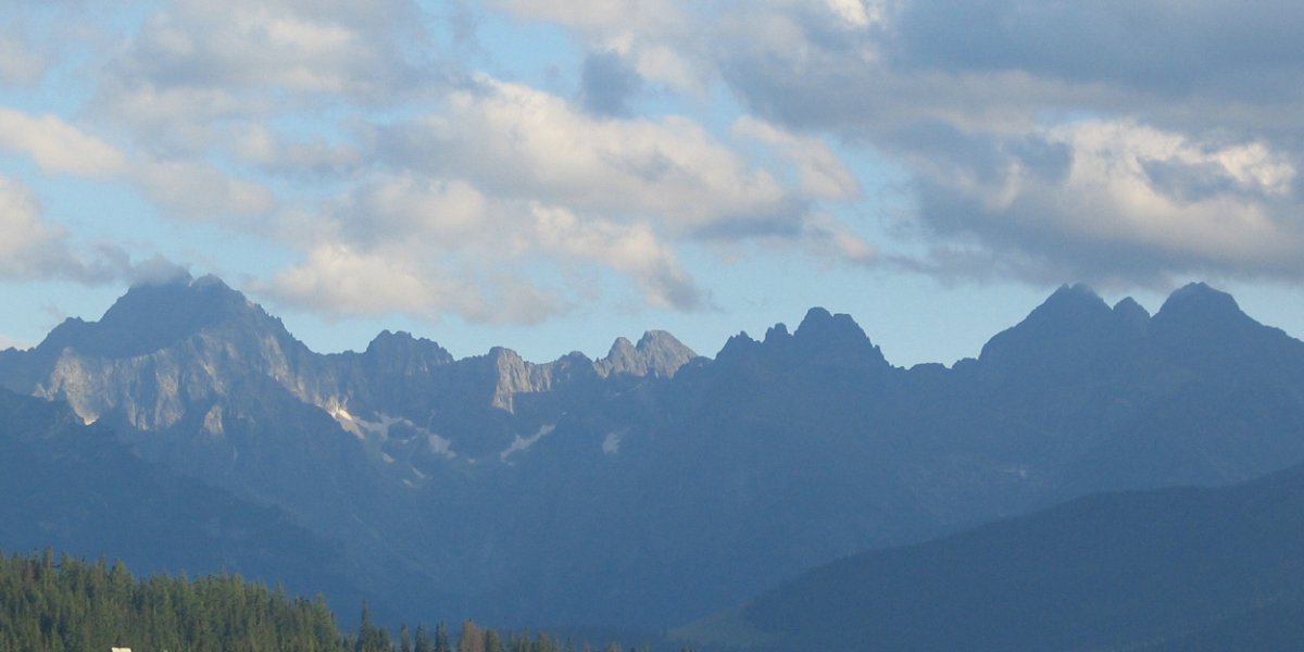
High Tatras
Eslovaquia · Best time to visit: Jun-Sep, Dec-Mar.
Day-by-day plan
Choose your pace
Duración del viaje
06:30
Park
Drive or train in at first light: Slovakia's most photographed glacial lake sits at 1,346 m, and at 06:30 it is pure glass — no wind, no coaches, the granite teeth of Solisko and the Mengusovska valley printed perfectly upside down in the water. Walk the 2.5 km wooden boardwalk counterclockwise so the highest peaks stay in front of you, and take the postcard frame from the southwest shore where reeds and pines anchor the foreground. By 09:00 the first buses arrive and the mirror is gone — this is the only window.
Tip: The textbook reflection shot is from the boardwalk just past Hotel Patria on the south-west bank — five minutes from the train station. Shoot before 07:30: after that the morning thermals ripple the surface and the mirror breaks for the day.
Open in Google Maps →08:30
Park
Pick up the red-blazed Tatranska Magistrala trail at the east end of Strbske Pleso and head into the silent spruce forest — 4.5 km of gentle climb, marmots whistling overhead, the Mengusovska valley slowly opening to your right. The path delivers you to a wilder, darker lake cradled in a glacial bowl beneath Ostrva peak. Walk the half-kilometre shoreline loop, then take the side trail up to the Symbolic Cemetery, a haunting forest clearing of hand-carved wooden crosses honouring climbers who have died in these mountains since 1936. Five minutes there explains why locals speak of the Tatras with respect.
Tip: The Symbolicky Cintorin (Symbolic Cemetery) is 15 minutes uphill from the lake on the signed yellow spur — most day-hikers miss it entirely, and it is the most moving spot in the park. Every plaque was carved by the dead climber's own friends; read a few before you leave.
Open in Google Maps →12:00
Food
Step from the shoreline path straight onto the chalet's lakeside terrace — a stone-and-timber mountain hotel that has fed hikers since 1879, and where the menu has stubbornly refused gentrification. Order bryndzove halusky, Slovakia's national dish of soft potato dumplings drenched in salty sheep cheese and crowned with crispy bacon (€9), with a bowl of kapustnica — smoked-pork sauerkraut soup that tastes like a fire in winter (€5). At this altitude after a 5 km hike, it is genuinely the best meal in Slovakia.
Tip: Sit on the rear terrace facing the lake, not the entrance courtyard. The kitchen closes hard at 14:30 — arrive by 12:30 or you risk a cold plate. Cash gets you served faster than card; bring small euro notes.
Open in Google Maps →14:30
Landmark
Hike 4.5 km back down to Strbske Pleso station (one easy hour, mostly downhill through the same forest), board the TEZ electric railway 35 minutes east to Tatranska Lomnica, then ride the big cable car 12 minutes up to Skalnate Pleso — your legs have earned the lift. The cabin spills you onto a 1,751 m alpine plateau cradling a small dark lake, with the white domes of the Skalnate Pleso astronomical observatory perched on the ridge above. The full massif unfolds eastward: Kezmarsky stit, the Belianske Tatras, the green Spis plain falling away into Poland. This is the warm-up before the summit.
Tip: Walk five minutes left of the cable car building to the observatory ridge — most visitors stay clustered at the lakeside snack bar, but the eastern panorama from the observatory bench is the photograph. Bring a windproof shell: it is 15 degrees cooler up here than in the valley.
Open in Google Maps →15:30
Landmark
From Skalnate Pleso, transfer to the smaller 15-person pendant cable car — a separate ride from the big one, swinging up the granite face in eight vertical minutes that feel like ten. At 2,634 m, Lomnicky stit is the second-highest peak in Slovakia and the only one you can stand on without ropes. The summit platform is barely bigger than a kitchen: on a clear afternoon Poland and Hungary are visible to the north and south, and on most days you stand inside a cloud watching it tear apart in real time. You get a fixed 50-minute slot — exactly the right amount.
Tip: This upper cable car MUST be reserved online at vt.sk at least two days ahead — only 50 seats per hour and it sells out every summer day. Book the 15:30 slot specifically: morning is often whiteout, and the afternoon clouds reliably tear open between 15:00 and 17:00.
Open in Google Maps →19:00
Food
Ride both cable cars back down (25 minutes total), then walk ten minutes through the village along the main street — you will smell the woodsmoke before you see the timber roof. A proper koliba of blackened beams, sheepskin throws and an open hearth, run by the same family for two generations and where the local mountain guides actually eat after work. Order the grilled rainbow trout, pulled the same morning from a Tatra stream and served whole with brown butter and dill potatoes (€18), and a plate of pirohy stuffed with bryndza sheep cheese and topped with bacon crackling (€12). Finish with a shot of borovicka — Slovak juniper spirit that cuts a 16 km day off your legs in one swallow.
Tip: Reserve for 19:00 at kamzik-tatry.sk — the dining room holds twelve tables and walk-ins are turned away by 19:30. Pitfall warning: skip the 'traditional' wooden food stalls clustered between the cable car base and the village — they microwave frozen halusky at €15 a portion, and the elegant Grandhotel Praha restaurant next door charges double for the same dishes Koliba Kamzik serves with more soul.
Open in Google Maps →Saltar al día
08:30
Landmark
Begin at the cable car base station in Tatranska Lomnica — a 3-minute walk from the train stop, follow the brown wooden signs uphill through the spruce. The two-stage ride lifts you 1700 vertical metres in under thirty minutes, ending on a knife-edge granite summit at 2634 m where Poland spreads to one horizon and the Slovak plain to the other. Catch the first car of the day: by 10:30 the summit usually buckles under cloud and the half-hour booked slot at the top fills with school groups.
Tip: The summit-cable ticket is a timed 50-minute round-trip and sells out 2-3 days ahead in July-August — book on vt.sk before you leave home, not at the counter. Wear a fleece even in August; the summit hovers around 5 C and the wind cuts through anything thinner.
Open in Google Maps →11:00
Park
Step off the cable car mid-station and walk 80 metres south to the rim of the tarn — the granite walls of Lomnicky and Kezmarsky Stit rise straight out of the water in front of you. Loop the lake clockwise on the wooden boardwalk (about 25 minutes) so the white domes of the observatory frame the peaks behind you; this is the postcard shot every Slovak knows. Mid-morning sun lights the cliffs face-on, and the marmots are usually out on the scree to your right.
Tip: There is a tiny window at the back of the Encian mountain hut selling hot tea with rum (caj s rumom, 3 EUR) — order it and walk the boardwalk with the glass in hand. Locals do this; tourists queue at the cafeteria and miss the view.
Open in Google Maps →13:00
Food
Ride the cable car back down and walk 4 minutes east along Cesta Slobody — the timber-framed koliba sits on the left, smoke already rising from the grill. This is where the cable-car mechanics eat: order bryndzove halusky (potato dumplings smothered in fermented sheep cheese with bacon, 11 EUR) and a bowl of kapustnica (sauerkraut soup with sausage and dried mushrooms, 7 EUR). Wash it down with a half-litre of Tatran tmavy, the dark lager brewed at Poprad.
Tip: Halusky is meant to be eaten the moment it arrives — the bryndza cheese turns gluey if it cools. Don't wait for everyone's plate; the waiter expects you to start immediately.
Open in Google Maps →14:45
Museum
A 6-minute walk west from the koliba, the museum hides in a low stone building beside the railway crossing. The collection is small but uncommonly good: a complete brown-bear skeleton, the actual rope and ice axe from the 1955 first winter ascent of Gerlach, and a back room of stuffed chamois and lynx in dioramas that have not been updated since the 1970s — which is precisely their charm. Afternoon is the right time: the museum closes at 16:00 in winter, and you have just enough light afterward for the next stop.
Tip: Skip the ground-floor mineral cases (skippable) and head straight upstairs to the alpinism room — the photographs of the 1924 cable-car construction crews working in waistcoats and leather boots are the museum's quiet masterpiece.
Open in Google Maps →16:30
Park
Hop on the electric Tatra train (TEZ line) two stops west to Stary Smokovec — 12 minutes, runs every 30 — then walk 3 minutes uphill to the funicular base. The 1908 funicular climbs 250 m through pine forest in 7 minutes; at the top, follow the green-marked trail 15 minutes down to Studenovodske vodopady. Late afternoon sun strikes the lower cascade through the trees and the day-trippers have already gone home, so you often have the falls to yourself.
Tip: Buy the one-way-up funicular ticket only and walk back down on the blue trail to Stary Smokovec (40 minutes, all downhill, no navigation needed) — it saves 9 EUR and the forest descent at golden hour is the better half of the experience.
Open in Google Maps →19:30
Food
Take the TEZ train one stop back to Tatranska Lomnica and walk 5 minutes east — the koliba glows orange behind a wall of split logs. This is the Tatra hunters' table: order the divinacie gulas (venison goulash with bread dumplings, 18 EUR) and the smoked trout from Popradske Pleso (14 EUR). The accordion player works the room from 20:00 onward; he takes requests if you tip 5 EUR.
Tip: Reserve the same morning by phone (+421 52 446 7253) — twelve tables, locals know it. Pitfall warning for the wider Tatranska Lomnica strip: avoid any restaurant on the main road advertising 'Slovak Folk Show' on a chalkboard outside — they charge 35 EUR for the same halusky you ate at lunch for 11.
Open in Google Maps →08:30
Park
Arrive on the first TEZ train of the morning — the platform empties out and you walk 4 minutes downhill through the larch trees to the lake's wooden pier. At 8:30 the water is still and the entire ridge of Krivan, Solisko and Patria stands inverted on the surface; an hour later the breeze comes up and the reflection breaks for the day. Walk the 2-km boardwalk loop counter-clockwise so the peaks stay on your left and the rising sun behind you.
Tip: The official photo spot is the pier in front of Hotel Kempinski, but the truer reflection shot is from the small wooden jetty on the south-east corner — bear right at the boat-rental kiosk and follow the dirt path 80 metres. No one stands there before 09:00.
Open in Google Maps →10:30
Park
Pick up the red Tatra trail at the eastern end of Strbske Pleso (signed 'Popradske pleso — 1h 30 min') and follow the gentle forest ridge eastward. The path is broad gravel, almost flat for the first kilometre, then rolls through a clearing where you see Kriva to the south — locals call this the 'Magistrala light'. After about 75 minutes the trail drops into a granite amphitheatre and Popradske Pleso opens below you, deeper and wilder than Strbske, with a single stone hut on the shore.
Tip: Wear ankle-supporting shoes, not sneakers — the last 200 m down to the lake is loose root and rock. Bears do come through this corridor; clap or talk loudly between groups, never use headphones. The drinking fountain at the trailhead by the railway is the last potable water until the hut.
Open in Google Maps →13:00
Food
The mountain hotel sits on the lake's southern shore — no walking transition needed, the trail delivers you to the front terrace. The cooks here feed climbers heading for Rysy, so portions are calibrated to people who have walked since dawn. Order the gulasova polievka in a hollowed bread loaf (9 EUR) and the pirohy s bryndzou (sheep-cheese dumplings with crispy bacon, 12 EUR), and grab a wooden table on the terrace facing the lake — wall of granite, glass of Zlaty Bazant, the day's quiet centre.
Tip: Cash works better than card here — the signal drops below 1494 m and the terminal sometimes refuses to authorise. Bring 30 EUR in small notes so you don't hold up the queue behind you.
Open in Google Maps →14:30
Religious
From the lake terrace, follow the yellow-marked trail 8 minutes uphill behind the hut — the path climbs through Swiss pine onto a granite shoulder. The Symbolicky cintorin is a hillside of hand-painted wooden crosses and slate plaques, each one for a climber who died in these mountains, the oldest from 1900. There are no bodies — only names and dates and short Slovak phrases. Afternoon is right: the western light catches the painted crosses, and the cemetery is empty after lunch crowds head down.
Tip: Read the plaque by sculptor Otakar Stafl himself — he founded the cemetery in 1936 and died on Gerlach two years later; his own cross is third row, far left. Speak quietly: Slovak hikers treat this as sacred ground, not a tourist site.
Open in Google Maps →16:00
Landmark
Walk back to Strbske Pleso on the same red trail — 70 minutes downhill — then 5 minutes west along the lake to the Solisko chairlift base. The open chair lifts you to 1840 m in 12 minutes; at the top, a 10-minute path leads to the Predne Solisko viewpoint at 2093 m. Late afternoon is the only right time: the sun drops behind Krivan to the west and lights the whole eastern wall of the Tatras in molten copper for about twenty minutes around 18:00 in summer.
Tip: Last chairlift down is 17:00 in low season and 18:30 in July-August — check the board at the bottom station and time your descent precisely; missing it means a 90-minute walk down a steep ski piste with no lighting.
Open in Google Maps →19:15
Food
From the chairlift base, walk 6 minutes north along the lakeshore path — the koliba is built into the hillside below Hotel Patria with a giant open hearth visible through the windows. End the trip on grilled meat over beech wood: order the jahnacie rebra (lamb ribs with garlic and rosemary, 22 EUR) and a starter of ostiepok (smoked sheep cheese grilled with cranberry, 8 EUR). The Tokaj from the Slovak side of the border (12 EUR a half-bottle) is the right pairing — drier than the Hungarian, almost no one orders it.
Tip: Reserve before 17:00 the same day (+421 52 478 8888); the hearth-side tables go to whoever calls first. Pitfall warning at Strbske Pleso: the souvenir stands near the train station sell 'genuine Tatra honey' and 'wolf-claw amulets' — both are imported tat from Poland marked up 400 percent. If you want real honey, buy it from the woman with the white apron at the small kiosk by the boat rental, not from the painted booths.
Open in Google Maps →
Trip builder
Plan this trip around High Tatras
Turn this guide into a bookable rail itinerary with FlipEarth.
Keep exploring
Related cities
More in the same country
FAQ
Frequently asked questions
How many days do you need in High Tatras?
Most travelers enjoy High Tatras in 1 days, with enough time for headline sights and a slower meal or museum stop.
What's the best time to visit High Tatras?
The easiest season for most travelers is Jun-Sep, Dec-Mar, especially if you want good weather and manageable crowds.
What's the daily budget for High Tatras?
A practical starting point is about €120 per person per day before hotels, then adjust based on museums, dining, and transport.
What are the must-see attractions in High Tatras?
A good first shortlist for High Tatras includes Skalnate Pleso, Lomnicky Stit Summit.